Put-in-Bay Airport South Bass Island
The Key West Of the North!

A Flying Adventure-Packed Full Of Fun!
Fly into Put-in-Bay Airport; We’re Waiting For You!
Put-in-Bay Airport (FAA LID: 3W2) is a public airport located in Put-in-Bay on South Bass Island in Ottawa County, Ohio, United States.
It is operated and managed by the Put-in-Bay Township Port Authority. The approach to Runway 21 is complicated by Perry’s Victory and International Peace Memorial, which is almost precisely in line with the runway.
The airport is located in the center of the island’s southern half and offers two runways 3 and 21. A taxi can pick you up on arrival, or better yet, and you can reserve a golf cart online to get around the island at Put-in-Bay Golf Carts
Put-in-Bay’s airport is open year-round for arrivals and departures from dawn to dusk and is the lifeline to islanders in the winter months. In the winter, all supplies and everyday conveniences such as mail, fresh produce, and milk must be flown in.
Runways at the Put-in-Bay airport are modern and paved but not lighted, so there are no departures after dusk. You may expect light turbulence on approach when winds exceed 10 knots. Be sure to remain at least 1000 feet from Perry’s monument, located 1.5 miles northeast of the field and having an elevation of 942 feet MSL.
The Put-in-Bay airport has no fuel service, but it may be purchased from the nearby Erie-Ottawa Regional Airport (FAA LID: PCW). The Put-in-Bay airport provides charter services thru Griffings Island Airlines, & Island Air Taxi. Refreshments (vending) and restrooms.
Credit cards are accepted. International arrivals must clear customs in Port Clinton (PCW) before landing on the island, as there are no customs agents. There is a small fee for parking which should be paid upon arrival. In the busy summer, several barnstorming vendors operate on the field, including helicopter rides and Bi-Plane rides.


Put-in-Bay Golf Cart Rentals Are How We Travel About The Island!
With very limited parking (who wants to pave over paradise?) We use Golf Cart Rentals To Travel The Island! Be sure to reserve your golf cart rentals online before arriving by clicking here:
Put-in-Bay Airport Information
Plan Your Perfect Put-in-Bay, Ohio Island Airplane Getaway Today!
FEDERAL AVIATION ADMINISTRATION INFORMATION EFFECTIVE 07 DECEMBER 2017
Location
FAA Identifier: 3W2
Lat/Long: 41-38-12.0000N / 082-49-42.0000W
41-38.200000N / 082-49.700000W
41.6366667 / -82.8283333
(estimated)
Elevation: 595 ft. / 181.4 m (surveyed)
Variation: 07W (2000)
From city: 1 mile SW of PUT IN BAY, OH
Time zone: UTC -5 (UTC -4 during Daylight Saving Time)
Zip code: 43456
Airport Operations
Airport use: Open to the public
Activation date: 12/1938
Control tower: no
ARTCC: CLEVELAND CENTER
FSS: CLEVELAND FLIGHT SERVICE STATION
NOTAMs facility: CLE (NOTAM-D service available)
Attendance: UNATNDD
Wind indicator: yes
Segmented circle: yes
Landing fee: yes, PARKING/RAMP FEES ARE COLLECTED FOR ALL PVT AND COML ACFT. ALL PILOTS ARE RQRD TO CHECK INTO THE ARPT OFFICE AT THE TIME OF ARRIVAL. NO TIE-DOWN ROPES PRVDD; BRING YOUR OWN ROPES. ALL ACFT RQRD TO SHUT DOWN ENGINE(S) WHEN ENPLANING/DEPLANING PAX.
Airport Communications
CTAF/UNICOM: 122.8
WX AWOS-3 at PCW (7 nm S): 118.775 (419-734-9955)
Nearby radio navigation aids
VOR radial/distance VOR name Freq Var
DJBr304/34.3 DRYER VOR/DME 113.60 05W
YQGr186/36.8 WINDSOR VOR/DME 113.80 06W
CRLr134/37.4 CARLETON VOR/DME 115.70 03W
VWVr075/38.0 WATERVILLE VOR/DME 113.10 02W
NDB name Hdg/Dist Freq Var ID
PORT CLINTON 021/7.3 423 07W PCW .–. -.-. .–
GROSSE ILE 160/31.4 419 07W RYS .-. -.– …
TIFFIN 033/36.9 269 05W TII – …
Airport Services
Parking: tie-downs
Airframe service: MAJOR
Powerplant service: MAJOR
Runway Information
Runway 3/21
Dimensions: 2870 x 75 ft. / 875 x 23 m
Surface: asphalt, in excellent condition
RUNWAY 3 RUNWAY 21
Latitude: 41-38.001702N 41-38.398105N
Longitude: 082-49.870983W 082-49.528005W
Elevation: 592.2 ft. 594.5 ft.
Gradient: 0.4% 0.4%
Traffic pattern: right, left
Displaced threshold: 450 ft. 657 ft.
Markings: basic, in good condition basic, in good condition
Runway end identifier lights: no no
Obstructions: 68 ft. trees, 404 ft. from the runway, 3:1 slope to clear
APCH RATIO 7:1 TO DSPLCD THLD DUE TO +43 FT TREE 303 FT FM THLD 133 FT R. 7 ft. fence, 201 ft. from runway, 120 ft. right of centerline
7 FT FENCE O FT DSTC, 120L; 4 FT FENCE 0 FT DSTC 110R.
Airport Ownership and Management from official FAA records
Ownership: Publicly-owned
Owner: PUT IN BAY TOWNSHIP PORT AUTH
PO BOX 278
PUT IN BAY, OH 43456
Phone 419-285-3371
PO BOX 278
PUT IN BAY, OH 43456
Phone 419-285-3371
Airport Operational Statistics
Aircraft based on the field: 9
Single-engine airplanes: 9
Aircraft operations: avg 41/day *
48% air taxi
42% transient general aviation
10% local general aviation
* for a 12-month period ending 12 June 2016
Additional Remarks
– EXPC MDT TURBC ON DEP/APCH WHEN WIND EXCEEDS 10 KT.
– ACFT LNDG RY 21 OR DEP RY 03 REMAIN 1000 FT CLEAR OF PERRY’S MONUMENT 352 FT AGL/942 FT MSL 1-1/2 MILES NE OF ARPT.
– ACFT OPNS PROHIBITED DUSK-DAWN.
– NO TGL.
– HELIPAD IS FOR TOUCHDOWN, LOADING, AND LIFT-OFF ONLY – PARK ON GRASS.
– BIRD ACTIVITY NR RY 3/21.
– BIRD ACTIVITY ON AND INVOF ARPT.
– DECOY COYOTE NEAR MOVEMENT AREAS.
Airport Communications
CTAF/UNICOM: 122.8
WX AWOS-3 at PCW (7 nm S): 118.775 (419-734-9955)
Put-in-Bay Airport News
$3.5 Million Award for Erie and Ottawa County Airports
In late August, Congresswoman Marcy Kaptur (D-OH-09) released the following statement after the Federal Aviation Administration (FAA) announced a series of grants totaling $3,541,777 for the Put-in-Bay Airport and the Middle Bass Island Airport. The grants were made available to regional airports due to the passage of the American Rescue Plan Act, supported by Rep. Kaptur, and signed by President Biden on March 11, 2021.
“Our regional airports play a vital role in supporting the local economy and connecting our communities,” said Rep. Kaptur. “I am excited to see the American Rescue Plan living up to its promise, and delivering the resources Northern Ohio needs.”
The announced FAA grants include:
• $147,381 for the Put-in-Bay Airport to reconstruct a
terminal building.
• $2,888,618 for the Middle Bass Island Airport to rehabilitate
an apron, runway, and taxiway.
• $359,605 for the Kelleys Island Land Field Airport to
conduct an environmental assessment.
• $146,173 for the Kelleys Island Land Field Airport to
rehabilitate a runway and reconstruct lighting.
Important Things To Know About Put-in-Bay!
Check Out Our Most Popular Pages!
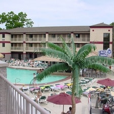
Put-in-Bay Places To Stay
From Fine Hotels To Resorts, Rental Homes To Campgrounds. Everything You Need To Know About Vacation Accommodations And Lodging At Put-in-Bay!

Put-in-Bay Attractions
From Mild To Wild, Educational to Adventurous, Put-in-Bay Offers Attractions For Visitors Of All Ages! Learn About Things To Do At Put-in-Bay And Plan Your Vacation Getaway Today!!
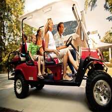
Put-in-Bay Golf Cart Rentals
At Put-in-Bay, We Utilize Golf Cart Rentals To Get Around The Island. Explore Our Golf Cart Options, And Be Sure To Reserve Your Ride Online Before Arriving!
John D.
Sarah M.
Mike G.
Larry P.
Marion D.
Lillian J.
Keith M.

Your Text Goes Here